Hãy tưởng tượng một thung lũng xanh, hơi dài hơn rộng. Xuyên qua giữa là sông Sông Re, chảy nông qua những tảng đá và ghềnh vào mùa khô nhưng dữ dội và thường không thể vượt qua vào mùa mưa. Sàn thung lũng có địa hình như một sân golf, trải dài đến những ruộng bậc thang ở dưới chân các ngọn núi bao quanh thung lũng. Ở một đầu thung lũng, xa xa, một thác nước đổ xuống từ đỉnh một dãy núi, rơi gần nửa đường xuống đáy trước khi hoà mình vào các tán cây. Hàng chục con trâu nước đang gặm cỏ gần các suối và ao. Sương mù và mây lăn lộn, trượt lên trượt xuống các ngọn núi suốt cả ngày... chưa bao giờ đứng yên quá một giờ. Đột nhiên, nửa thung lũng biến mất trong làn sương trắng; 60 phút sau, chỉ còn những đốm mây nhỏ trôi lững lờ nửa sườn đồi. Ở đằng kia, một đám sương mù dài và mỏng chảy xuống một thung lũng hẹp dài, cuối cùng quấn quanh một trong các thôn nhỏ rồi cuộn lại thành một khối và trôi đi. Một thế giới mơ mộng. Những ngôi làng dân Thượng Hre sạch sẽ và nhỏ bé trên những một ngọn đồi, trông giống như câu chuyện cổ tích của trẻ con về những ngôi nhà trong thung lũng cổ tích. Đây là Gia Vực, cách Đà Nẵng khoảng 80 dặm về phía tây nam và gần nửa đường đến Lào. Trại Lực lượng Đặc biệt là một trại cũ; các bãi mìn ở phía trước vẫn còn một số mìn Pháp, và một số thành viên bộ tộc Hre nói được một ít tiếng Pháp. Người Hre là một trong những phân nhóm lớn của dân Thượng với khoảng 150.000 người. Phần lớn không có nếp gấp của mắt người thượng, và hầu hết có mũi thẳng nhưng ngắn, không giống như mũi bẹt của phần lớn người Việt. Hầu hết người lớn (đặc biệt là những người già) đều đã mài hoặc gãy răng cửa trước, đây là một phong tục của bộ tộc. Một số gene Pháp vẫn hiện rõ ở một số người có làn da trắng và một số có tóc đỏ. Chạy qua giữa khuôn viên của chúng tôi là những mảnh còn sót lại của một con đường cũ của Pháp từng nối Kontum và Quảng Ngãi. Một ngày khi đi tuần tra, tôi thật sự ngạc nhiên khi thấy một tấm biển của con đường cũ, gỉ sét và đầy lỗ đạn, có ghi 'Kontum 25 km.' Ảnh của lính lực lượng DSCĐ từ Gia Vuc, do vẻ ngoài thư thái của họ, chắc hẳn họ đang gần trại (lưu ý tấm biển đường Pháp cũ). Cảm ơn Loyd Little, toán A-113 năm 1965 về các ảnh này. Lúa là cây trồng chính mặc dù trà, dừa, quế, mật ong, gai dầu và cau đều được trồng. Các loại cây mọc hoang gồm có chuối, mía, xoài và một loại cây giống bưởi. Một làng điển hình có khoảng 50-60 người sống trong 12-18 túp lều trên các ngọn đồi. Thức uống ưa thích là rượu đế khá mạnh. Tổng cộng có khoảng 1.000 người Hre sống trong một thung lũng dài này. Chỉ có một trường học trong thung lũng, được xây dựng bởi một nhóm Lực lượng Đặc Biệt Mỹ trước đó. Một giáo viên được tuyển từ Sài Gòn và được Lực lượng đặc biệt Mỹ trả lương. Người Hre đã chiến đấu từ đầu những năm 1950, một số với Pháp, một số với Việt Minh/Việt Cộng. Hầu gái của chúng tôi là một Việt Cộng bị bắt và (chúng tôi nghĩ là) được tuyển về phe chúng tôi. Cảm ơn Loyd về những ảnh này.
Sunday, October 19, 2025

Camp Gia-Vuc was one of the oldest SF camps in the 1st CORPS It was an old French camp (Indochina War) reopened by USSF in February 1962 BU A-5/1, to secure a population of 1500 HRE montagnards and about 300 Vietnamese in that area. The camp is situated near the Song Re river in the Quang Ngai province, about 80 miles from Danang and was originally in the II CORPS Tactical Zone but in 1964, the I and II CTZ borders were adjusted and the camp came under control of the I CTZ. Gia -Vuc was the southernmost camp in the 1st CTZ and its mission was surveillance and interdiction on infiltration routes. The Song Re valley know as Vietcong Valley was one of the major enemy supply/infiltration routes from Laos Eastwards to the Vietnamese costal lowlands.
It is believed that Gia-Vuc made a lot of Civic Action progress and improvements in the area and encountered more than their fair share of VC. When the camp was handed back to LLDB in 1969, there were approximately 6400 Hre and Vietnamese living in the area. Gia-Vuc was also known as the "Shangrila" of Vietnam and was becoming the social, cultural and political center of the Hre Montagnards. Colonel Harold R Aaron referred to Gia-Vuc as the most successful SF camp in Vietnam.
During most of its life, the camp lacked artillery, but at some stage had recoilless rifles to ward off enemy attacks. The camp defenses were virtually probed every night and suffered regular mortar attacks. Later on,
the fighting trenches were hardened against mortar attacks by concrete capping of trenche and bunker system. Due to tropical rain storms flooding was not uncommon.
"An interesting fact about Gia Vuc is that, after it was turned over to the ARVN Rangers, it was besieged by PAVN as part of PAVN's invasion of RVN. The Rangers fought to the last man there, some 300 KIA or MIA." This additional information is thanks to Alex Humphrey (5th SFGA, Ba To 1964-65)
Imagine a green valley, slightly long than wide. Weaving through the middle is the Song Re river, running shallow over rocks and rapids during the dry season but fierce and often impossible to ford in the rainy season. The floor of the valley has the terrain of a golf course, rolling into terraced rice paddies at the bottoms of the mountains ringing the valley. At one end of the valley, far in the distance, a waterfall pours off the top of a ridge, falling nearly halfway to the bottom before losing itself in the trees. Dozens of water buffalo graze near the streams and ponds. The fog and clouds roll and tumble and slide up and down the mountains all day long...never remaining stationary for more than an hour. Suddenly half the entire valley is invisible in misty white; 60 minutes later only little puffs float halfway up the hills. Over there, a long skinny finger of fog flows down a long narrow valley, finally wrapping itself around one of the hamlets and then curling itself into a ball and floating away. A dream world. The Hre Montagnard villages perch clean and tiny on little hills, looking like a child's story of fairy-tale houses in a fairy-tale valley.
This is Gia Vuc, about 80 miles southwest of Danang and about mid-way to Laos. The Special Forces camp is an old camp; the minefields in front still have some French mines in them and some of the Hre tribesmen speak a little French. The Hre are one of the large subgroups of the Montagnards with an estimated 150,000 people. Most do not have the epicanthal eye fold, and most have a straight though short nose, not the flatter nose of most Vietnamese. Most adults (especially the older) have had their front teeth either filed down or broken off, a tribal custom.
A few French genes visible in some who have white skin and some who have red hair. Running through the middle of our compound are bits and pieces of an old French road that once linked Kontum and Quang Ngai. One day on patrol, I was amazed to see an old highway sign, rusty and full of bullet holes, that read "Kontum 25k."
Photo of CIDG's from Gia Vuc, due to their relax look, they must be closed to the camp
(note the old French road sign) Photo, thanks to Loyd Little, A-113, 1965
Rice is the primary crop although tea, coconuts, cinnamon, honey, hemp and areca palm are grown. Growing wild are bananas, sugar cane, mangoes and a grapefruit-like plant. A typical hamlet has 50-60 people in 12-18 huts perched on hills.
Favorite drink is a quite potent rice wine.
Altogether about 1,000 Hre live in this one long valley. There is only one school in the valley, and it was built by an earlier SF team. A teacher was recruited from Saigon and is paid by SF. Hre have been fighting since the early 1950s, some with the French, some with the Viet Minh/Viet Cong. Our housegirl is a captured Viet Cong and recruited (we think) to our side.
Description of Gia Vuc is thanks to Loyd Little Sr Medic (E-6) at Gia Vuc
(A-113 Sept. 8 to Nov. 2, 1965)
Tuesday, September 9, 2025
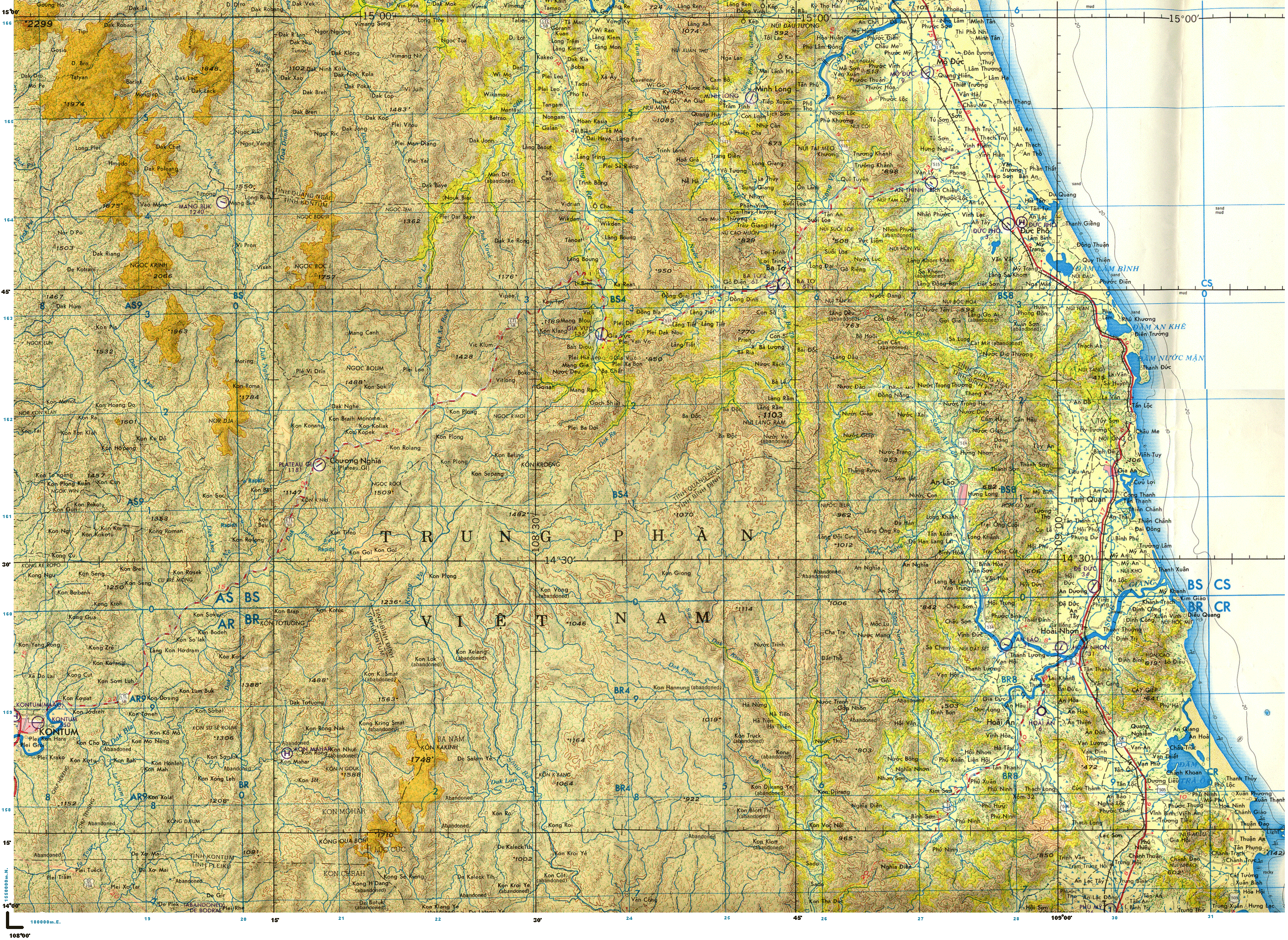
Gia Vuc and the Song Re valley Nguồn: Welcome to the Gia Vuc Website Bản đồ sau đây về vùng đông bắc của tỉnh lỵ Kontum, có làng Kon-Sơm-Luh, nơi xảy ra trận đánh lớn, sau HĐ Paris 1973, được nhắc đến trong các bài viết của Vương Mộng Long, Vũ đình Hiếu, Phạm Tín An Ninh, v.v... Một bản đồ cũng về vùng đông bắc Kontum: ND495MAP2insert.gif (1493×1106) Một bản đồ vẽ từ thời Pháp: New Page 1
Photo of a Viet Minh flag donated by a friend of my father. On the flag lay two daggers and some French GCMAnd Para insignias Since having learned in the 90's about the French mine field around Gia Vuc and the hard standing building which became the infirmary, I always wonder if its USSF A-teams were walking in the footsteps of a French unit which would have been garrison there 10 years earlier? Back in the late 40's and early 50's the Song Re valley and villages likes Gia Vuc, Bat To, Ha Thanh where under firm Viet Minh control. The situation was pretty reversed from the one in the 60's. The French forces in the central highlands were under strength and ill equipped, for the French high command this was not an important theater of operation and therefore received low priority on men and equipment. The French where strongly implanted around Kontum and Ban Me Thuot but were only able to organizing raiding parties on area further north. One of their most northern outpost was Kon Plong where a lot of the operations started from. Here is a list of some of the recorded operations they did. (please note there is probably more and the period from 1953 -54 is unknown but this is all I have found so far) Operations relating to Gia Vuc with the 4e BMEO, 1949-1951 This come from a French man who has retraced the two tour of duties (just under 5 years) of his uncle Maurice Millour in Indochina. http://philippe.millour.free.fr/index.html On his first tour (37 months, 1948-51) Maurice Millour served with the 1/3ème BMEO and then 16e/4ème BMEO (16th Company, 4th Battalion de Marche Extreme Orient) at the outpost of The Kon Plong outpost was surrounded by a vast expanse of forests and mountains, it was built on a small hill above a large valley housing a Montagnard village. The outpost was entirely made of logs, with the exception of two brick buildings and a few tin roofs. The main building was approximately 25 m long and 5 to 6 m high and wide with at one end the infirmary and the other end the radio room. Its most vulnerable part was the one facing the meadow and was made of a log wall pierced with fire ports. The post's enclosure was also made of logs: two parallel walls spaced 60 to 70 cm apart, filled with pebbles and earth, all reinforced with split bamboo set between the logs to limit erosion by rain. The build was carried out without a single nail and was held together with braided rattan. During heavy showers, running water did erode its construction resulting in holes which for ever needed filling up.
The combat companies had a strength of around 173 men organised into 4 platoons with 3 squads per platoon. Each company had 2 French Officers, around 15 French or indigenous NCO and another 10 French corporals or PFC or soldiers. The montagnards were spread within the four companies according to their ethnic. 14 &16th been Sedang, the 15th Djarais and the HQ and the 13e with a mixture of both ethnics. Armament of the 16th Co comprised of one heavy machine gun FM 24.29, a 120mm mortar in Kon Plong oupost, one 50m mortar for external operations, and a few grenade launchers. The NCO had
1949 Early in 1949 Lieutenant Jaques Pierre arrived in Ban Me Thuot operational area and in February took command of the Kon Plong garrison which was under strength. On the 25th of May, Lt Pierre left the Kon Plong outpost at the head of reinforced platoon of about 50 men, including seven Europeans. During this operation which did last two days, this small troop reached the
On October 14, a reconnaissance party send in the Song Re Valley three days earlier returned to the Kon Plong outpost. They had been ambushed twice, north of Gia Vuc and east of Kon Plong, resulting into one KIA and two WIA. During the two ambushes, PFC Bellei, a Kon Plong medic who accompanied the patrol, rushed forward several times while under fire to attend the wounded. For his bravery and dedication, he received 3 regimental citation with a Croix de Guerre with bronze star. The two wounded were evacuated the next day to
1950 In February 1950, Hre Montagnards who had been forcefully enrolled into the Vietminh People's Army revolted. After having killed their cadres and Viet Ming commissars, they approach French posts to ask for their protection. Among these posts was Kon Plong. Lieutenant Pierre, the young and new CO of Kon Plong quickly realise the potential of that situation and supported the Hre revolt. He also organizes volunteers into a Hre paramilitary units of partisans under the name of "Action Hre". On April 7 operation "Adrien" was launched to support the Hre uprising and to drive back Vietminh troops from the Song Re valley towards the coastal plain of Quang Ngai. This newly formed "Groupe Mobile" (Mobile Task Force) was made of about 600 men with detachments from the 2e BEP, the 1e
From 7 to 13 April, the group moves from Kon Plong to the village of Gilang via Vitiong, Viklum, Vipée, Dak Xérong, Monit, then the valley of Song Ré until Ta Ma, and finally Gilang. During this part of the operation, only forward element made sporadic contacts with the Viet Minh. From the 14th of April a landing strip, drop zones and a field first aid post were established in Gilang. Reconnaissance operations were launched in that area resulting in casualties for the 2ème BEP et du 2ème
A follow up operation "Gien" took place from 8 to 12 May. The operational element was another Mobile Task Force made up of the 15th and 16th Cie of the 4th BMEO, the "Compagnie de Marche" of the 1st The operation "Gien" did not succeed as much as the region was found empty of any significant number of enemies. Also the lack of trails, would have made the implantation of an outpost not viable due to being so much isolated without the chance of been rescued in time by road or trails. Following the "Adrien" operation, it was decided to organize part of the Hre into a structured military unit. This lead in mid-June to the creation in Kon Plong of Corporal Rene RIESEN from the 4e BMEO and author of " Mission spéciale en forêt Moï ".This is the only book regarding the French involvement with the Hre montagnards which had been translated into English (new title "Jungle Mission" in 1957). R Riesen received the task of supervising the Hrés volunteers, instructing them in guerrilla warfare and of forming villages self-defence groups [also known as "militia" or "goums"]. René Riesen did spend several years with the Hrés, becoming their war chief under the name "Ba Tamoï" (the father of Moïs), or "Ba tchiac gaho tabouac" (the white-haired father). One of Riesen's first missions was to form a unit of partisans in the In June, many trails improvement works were carried out in the sub sector of Kon Plong, either south to Kon Braih or north to Kon Kléang or Gia Vuc. On 31 December, the "Petits Hrés" self-defence group in the Mang Mou / Mang Rha area (Song Re Valley), armed with an FM, three MGs and one hundred and sixty rifles, turned themselves to the Vietminh following the betrayal of most of their troops. Early January, information confirmed by patrols indicated the presence of 400 Vietminh around Mang Mou and Mang Rha, and another 1,200 in the Gia Vuc valley. Gaston Mille commander of the 4th Montagnard battalion (the old 4th BMEO) decided to organize combat operation "Omer" in the form of a raid to the above Vietminh controlled area to recover all or part of the lost weapons as well as to collect information in view of a possible re-occupation of the villages of Mang Mou and Mang Rha. After 5 day of patrolling in and on the high ground of the Song Re valley, no contact was made with the enemy which had disappeared and the local population appeared non co operative and under Viet Minh control.
Operations relating to Gia Vuc with the GCMA, 1951-1952 By 1951, the CEFEO, "Corps Expéditionnaire Français en Extrême-Orient" had new counter-guerrilla units at its disposition thanks to their new commander in chief, General de Lattre de Tassigny. These newly formed counter-guerilla units were the “Groupement de Commandos Mixtes Aéroportés” (GCMA) and the Commandos Nord In autumn 1951, Cpt Hentic with 2 or 3 French cadres and a Hre forces of 150-200 men, carried out more raids deep into Viet Minh controlled territory. These raids lasted from three weeks to six weeks reaching places like Vidzen, Vibliang and Gi Lang and rallied more troops and population through the lower valleys of the Son Hre.
26 April 1952, Cpt Hentic with less than three Hre "three centaines" left Gia Vuc and crossed the Song Re on the 27th and attacked and took Ba To in the morning of the 2nd of May. They destroyed all V-M installations and ammunitions depots as well as the VM 108 Regiment headquarters. By the fall of 1952 with a Vietnamese Commando and a Hre platoon (approx 100 men), Cpt Hentic achieved a two months deep reconnaissance via Dak To into Laos leading to Attopeu. In its path, they destroyed Viet-Minh bases and laid booby traps on the Viet-Minh trails. During this reconnaissance mission they discovered in Laos a well camouflaged large tails network, Viet Minh staging and rest areas, food dumps etc. This was the first sighting of the famous Vietnam Ho Chi Minh trail! Unfortunately, this is all I have for the moment which lead us to the end of 1952 where trails leading to the valley of the Song Re and Gia Vuc were improved to facilitated a possible future French implantation to controlled that area. Information translated by myself come This is a fascinating part of Gia Vuc history and if you want to discover more regarding the French Special Forces and the 4th BMEO who both beat the bush in the Central Highlands, visit my French Indochina war section.
|


Names from the | Names identified on | Location |
Plaine de Gravuc | Plain of Gia Vuc | 15° 43' N - 108° 05'E Camp |
Mankra | Mangia |
|
Vikli | Vicli |
|
Viklun | Vic Klum |
|
Tama | Tamao |
|
Vi-Pe | Vipee |
|
Kon Plong | Kon Plong |
|
Mang Buk | Mang Buk |
|
| Ba To | Ba To | |
| Vi Muk | ? | |
| Gilang | ||
| Vidzen | ||
| Dak Ninh | ||
| ViHolac | ||
| Kola | ||
| Vibliang | ||
| Mang Mou | ||
| Mang Rha | ||
Regarding names and places, specially early during the war, they were very few maps and some of the names recorded may just had been written the phonetic way they were understood by the French. In the 60 's on US maps, the same village may have been written differently make it difficult to trace them. | ||