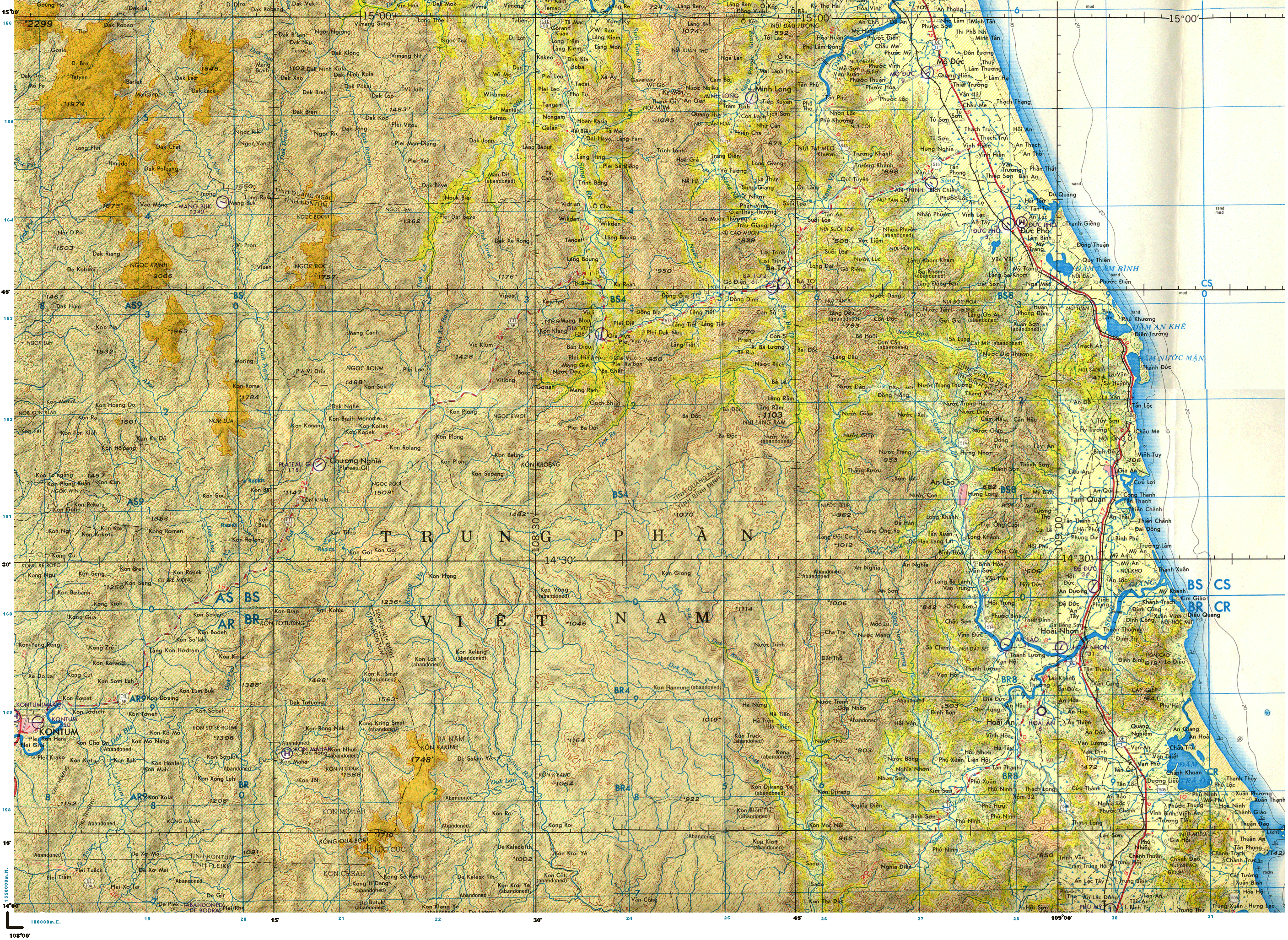
The vast majority of the locales are due west (across the Song Hre River) of Gia Vuc and somewhat south. It's interesting that Riesen made the sketch map most likely based on existing French maps trying to translate into French what he thought he understood the Montagnards to be saying. I don't think that the Montagnards had any written language (that I'm aware of), and their sense of distance would have been rather unsophisticated, i.e. not able to judge distances in other than "a short or long walk."
Beginning at the bottom of the sketch map working up (south to north)

1. Located the Dac Poe'ne' River. My map did not go far enough south to cover Kontum.
2. On the sketch map north of Dac Poe'ne' is another waterway, "K sat." This is most likely the Dak Xa Rack River. It's orientation on the sketch map is generally correct.
2. "Outpost of Kon Plong." On my topo are seven numbered hamlets (1-7) all with the name Kon Plong. This is not uncommon. They cover an area of roughly 10 square KM.
3. There is a "Vi Tring" north of one of the Kon Plong hamlets in generally the same alignment as what's on the sketch map.
4. On the sketch map north and slightly west of Vi Tring is a "Vik lun." On the topo it is Viklum in about the same orientation.
5. On the sketch map is a "N Brail Monome." It's that spelling and roughly in same orientation on the topo.
6. North of Vi Tring is the hamlet of K. klang and the "Mist Camp." The terrain is very rugged in this area and I assume the camp drew its name from being suspended in clouds and mist most of the time. The topo map has a Kon Klang north of Vi Tring but no ref to the Mist Camp. I assume the camp was close to Kon Klang. This general area is or was most likely in heavy multi layered canopy.
7. The "Hill Country" on the sketch map generally lines up with some very rugged straight up and down terrain on the topo, impassable most likely due to the contour interval.
8. Moving to the NE on the sketch map "Mankra" is most likely Mang Gia and a bit south of the actual Gia Vuc Camp as opposed to being superimposed on it like the sketch map depicts.
9. The "Plaine de Gravuc" is obviously the Gia Vuc camp and valley. Bato exists on the topo in generally the same orientation as on the sketch map except that it is slightly to NE vice due east.
10. Moving north along the Song Hre River, "Viblian" is actually Vidrian and generally in the same orientation.
11. Camp Pierre is actually on the top map. It is 8 KM north and 9 KM west of Gia Vuc and in a heavily canopied area.
12. the Dac Pe'e and Dac Xe'ron streams / rivers are oriented NW to SE on the sketch map, but actually more N and S on the topo (Dac Pe'e was not noted on the topo).
13. Continuing NE along the Song Hre on the sketch map, Tama is on the topo, and on my original 1:50,000 scale map (I don't have it at my current locale presently) there was an unimproved airstrip noted.
14. The NE corner of the sketch map is way out of proportion. On the actual topo Vimuk is some 30 KM north of Camp Pierre and slightly west. The DaK Drinh is correctly oriented on the sketch map but as noted a lot further north than depicted on the sketch. The old district capitol of Son Ha is correctly oriented along the Song Tra Khuc River (The Dak Drinh and Song Hre rivers converge and become the Song Tra Khuc)
15. In the upper left corner of the sketch is an arrow pointing N to Mambuk. It's actually Mang Buk. It is correctly oriented in terms of being a fair distance west of Gia Vuc but is not as far north as depicted on the actual topo. It's actually only slightly north of Gia Vuc.
So Rene Riesen operated mostly in the area immediately west and south of Gia Vuc in the 1950 / '51 time frame.
Map study by Robert M Hensler ,
Cpt MAT 1-27, Duc Pho District,
Quang Ngai Province, 1970
http://www.gia-vuc.com/hre/ND495MAP.gif
Cpt MAT 1-27, Duc Pho District,
Quang Ngai Province, 1970
http://www.gia-vuc.com/hre/ND495MAP.gif
No comments:
Post a Comment